🌋 A Complete Guide Backed by USGS Data
Hawaiʻi Island is one of the most volcanically active places on Earth, shaped by five massive volcanoes—Kīlauea, Mauna Loa, Hualālai, Mauna Kea, and Kohala. Because lava flows are a natural part of life here, the U.S. Geological Survey (USGS) created a system of lava flow hazard zones to help residents, planners, and homebuyers understand long‑term volcanic risk.
This blog breaks down what lava zones are, how they’re determined, and what they mean for people living on or moving to the Big Island—using verified information from the USGS.
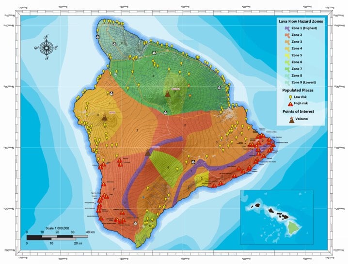
🌋 What Are Lava Flow Hazard Zones?
USGS divides Hawaiʻi Island into nine lava flow hazard zones, ranked from Zone 1 (highest hazard) to Zone 9 (lowest hazard). These zones are based on:
Eruptive history of each volcano, Frequency of past lava flows, Location of rift zones and vents and Topography that influences lava flow paths
The current map was originally developed in 1974 and revised in 1987, and it remains the standard reference today.
🗺️ The Nine Lava Zones Explained
Below is a clear breakdown of each zone, based on USGS descriptions and hazard assessments.
🔥 Zone 1 – Highest Hazard
These areas include the summits and rift zones of Kīlauea and Mauna Loa—where eruptions occur most frequently.
-
Most eruptions originate here
-
Lava can appear with little warning
-
Includes areas like Kīlauea’s East Rift Zone and parts of Mauna Loa’s Southwest Rift Zone
USGS notes that these regions have been repeatedly covered by lava in historical and prehistoric times.
🔥 Zone 2 – Very High Hazard
These areas are adjacent to rift zones and downslope from active vents.
-
Lava flows often reach these areas quickly
-
Includes large portions of Puna and Kaʻū
-
Historically, many communities have been impacted
Zone 2 areas have a high probability of lava inundation due to their proximity to eruptive sources.
🌋 Zone 3 – High Hazard
These areas are further downslope from rift zones.
-
Still at risk, but less frequently impacted
-
Lava flows may take longer to reach these areas
-
Includes parts of Hilo, South Kona, and Volcano Village
USGS notes that these areas have been covered by lava in the last 750 years, but less often than Zones 1 and 2.
🌄 Zones 4–6 – Moderate Hazard
These zones represent decreasing hazard levels as distance from active rift zones increases.
-
Zone 4: Areas on Mauna Loa and Kīlauea that have seen fewer flows in the last 10,000 years
-
Zone 5: Areas on Hualālai with moderate eruptive history
-
Zone 6: Areas on Mauna Kea with older lava flows
These zones still contain volcanic features, but the likelihood of future lava coverage is significantly lower.
🏞️ Zones 7–9 – Low Hazard
These zones include the oldest parts of the island.
-
Zone 7: Lower slopes of Mauna Kea
-
Zone 8: Kohala Mountain region
-
Zone 9: Northernmost tip of Kohala
These areas have not experienced lava flows for tens of thousands of years and are considered the safest in terms of lava hazard.
🌋 How USGS Determines Lava Hazard Zones
According to the USGS Hawaiian Volcano Observatory, lava hazard zones are based on:
Where past eruptions have occurred, How often eruptions happen, How quickly lava flows have historically moved
and Geologic mapping and flow modeling
USGS emphasizes that boundaries between zones are gradational, not sharp lines, meaning risk transitions gradually across the landscape.
🏡 Why Lava Zones Matter for Homebuyers
If you’re buying property on Hawaiʻi Island, lava zones affect:
1. Insurance Availability
Some insurers do not cover homes in Zones 1 and 2.
2. Mortgage Requirements
Lenders may require additional documentation or deny loans in high‑risk zones.
3. Infrastructure & Access
Roads, utilities, and emergency services may be more vulnerable in high‑hazard areas.
4. Long‑Term Planning
Understanding risk helps homeowners prepare for potential evacuations or disruptions.
🌱 Living Safely in Lava Country
USGS stresses that while lava flows are usually slow enough for people to evacuate safely, they can destroy everything in their path—homes, roads, forests, and entire communities.
Residents in higher‑risk zones often take steps such as:
-
Staying informed through USGS updates
-
Having evacuation plans
-
Maintaining emergency supplies
-
Understanding insurance limitations
💯Knowledge Is Power on Hawaiʻi Island
Lava zones don’t exist to scare people—they exist to inform smart decisions. Hawaiʻi Island is one of the most beautiful and geologically active places on Earth, and understanding lava flow hazards helps residents live safely and confidently.
Whether you’re a homebuyer, a new resident, or simply curious about the island’s volcanic landscape, USGS lava hazard maps offer essential insight into how the island was formed—and how it continues to evolve.
USGS – Lava Flow Hazard Zones and Flow Forecast Methods www.usgs.gov
